![]()
A Critique of Dr Tasman Walker's Flood Geology Model
Paul Blake
Paul completed his Bachelor of Science in 1989 at the University of Queensland majoring in geology, and his Honours in 1990 majoring in geology and palaeontology. Since 1991 he has worked for the Geological Survey of Queensland which is part of the Department of Mines and Energy, and is currently doing a PhD part-time on "The Middle Palaeozoic corals and tectonic evolution of central coastal Queensland".
He is a member of the Geological Society of Australia, Association of Australasian Palaeontologists, Petroleum Exploration Society of Australia, and the Australasian Evolution Society.Paul's website can be found here.
INTRODUCTION
Dr Tasman Walker works for Answers in Genesis and has a website dedicated to his attempt to reconcile the science of Geology and Palaeontology with his interpretation of Noah's Flood story in the Bible's Book of Genesis.
Many others have written articles [12] on the
impossibility of a global flood, therefore, for this article I will only be focusing on Dr
Walker's model.
THE MODEL
Dr Walker basically breaks up the geology of the world into 4 groups, all of which formed in the last 6000 years. A brief summary of his units is:
The biggest problem with Dr Walker's model is that he has started with the Bible story, made a model out of his interpretation of it, and then tries to force the data from the real world fit his model. This is the exact opposite of how science works. The first step is to collect data and then create your model to fit the data. Also, a scientist must be prepared to change a model if new evidence is found that does not fit the old model. Dr Walker has further removed his model from the realms of science by admitting that he will never accept any evidence that contradicts his Bible-based model [1]. He appears more interested in imposing a pre-ordained framework on geology than he is in understanding it.
As damning as Dr Walker's lack of objectivity with regard to the evidence is I will move on since the real test of any model is how well it works.
Even a brief look at his criteria shows that almost every rock found in the world will be considered a "Flood" rock. When compared to the complexity seen in the world through modern geology, Dr Walker's model appears childish. Some people prefer simplicity, but the fact remains that despite the complexity of modern geology, those who study it as their profession can understand it. As a tool, modern geology is highly successful at finding the oil, coal, and metal ores that are necessary for our modern society, thus proving its worth as a science. Since Dr Walker's model portrays all rocks as being due to one event, how would he be able to differentiate the rocks and know where to look for ore-bodies such as porphyry copper or volcanogenic massive sulphide deposits? These sorts of orebodies do not just occur anywhere. They are strongly constrained by their geological province, which is linked to the plate tectonic models of the Earth. Dr Walker's model does not allow for plate tectonics and province recognition, and would therefore be useless in mineral exploration or any form of scientific investigation.
THE INCONSISTENCIES IN DR WALKER’S MODEL
One major problem with Dr Walker's model is that he does not use it consistently. Dr Walker has stated that the fossils at Riversleigh were not the result of the flood and they would be from the New World Era. [2] The reason he states this is because, according to his model, it is impossible for the fossils produced during the flood to be related to the animals that now inhabit the continents, since the pre-flood continents and their faunas would have no resemblance to the modern continents. Since both the fossil fauna in the rocks at Riversleigh and the modern Australian fauna are dominated by marsupials, Dr Walker concludes that the rocks at Riversleigh must be New World Era. However, classifying the rocks at Riversleigh as New World Era ignores the geological evidence such as:
The Riversleigh locality contains abundant fossils.
The rocks that contain the fossils are an erosional remnant of the Wyaaba Cycle of the Karumba Basin. [3]
The Karumba Basin is very large, almost as big as the Great Artesian Basin (GAB).
The limestones containing the Riversleigh fossils occur at the top of flat mesa-like hills. [4]
All four of these criteria would fit Dr Walker's model as flood deposits eroded by the floodwaters as they receded off the continents. However, this evidence is ignored. Therefore Dr Walker needs to outline when the geological information is important for deciding where rocks fit into his model, and when the geology is to be ignored in favour of the fossil evidence.
THE GREAT ARTESIAN BASIN (GAB)
Dr Walker attempts to show that his model works for the GAB, however, in an attempt to make it fit his model he only presented some very simple evidence and ignored all the evidence that contradicted his interpretation.
PROBLEM 1 - ENVIRONMENT OF DEPOSITION
Dr Walker wants all rocks to be deposited in a single event (Noah's Flood). However, studying rocks in detail shows that they are deposited in a variety of environments. I will illustrate by using the Eromanga Basin, which is part of the GAB. It displays a pattern of rock deposition that is the same as in the whole GAB, but by focussing on only one part of the GAB I can reduce the number of geological formation names that are used within the GAB. A summary of the geology of the GAB [5] is given below, with the oldest formations at the bottom, and the youngest at the top.
Formation Name |
Thickness (m) |
Environment of Deposition |
| Winton Formation | 500 |
Fresh water rivers |
| Mackunda Formation | 100 |
Marine |
| Wilgunya Subgroup | 770 |
" |
| Longsight Sandstone | ~70 |
" |
| Gilbert River Formation | 50 |
" |
| Cadna-owie Formation | 60 |
" |
| Hooray Sandstone | 150 |
" |
| Ronlow beds | ~90 |
Fresh water rivers |
| Blantyre Sandstone | ~50 |
" |
| Injune Creek Group | 470 |
" |
| Evergreen Formation | 75 |
" |
| Precipice Sandstone | 120 |
" |
As you can see from the table above, the Eromanga Basin changes its environment of deposition several times. It starts terrestrial at the base, changes to marine in the middle, and finishes as terrestrial again. The basin is not one simple event as Dr Walker would like to portray.
Also, in this example Dr Walker fails to mention that the GAB is only a thin layer of sedimentary rock overlying other basins that would also have been deposited during Noah's Flood according to his model. Dr Walker just refers to them as "Basement Rock" and does not try to explain them. Even though the GAB is several kilometres thick in places, it is a relatively minor feature compared to some of the basins that were deposited before it. For example, in the central Queensland area the GAB overlies the Galilee Basin, which in turn overlies the Drummond Basin. The Galilee Basin is about 200m thick and mainly deposited by fresh water rivers, [5] and the Drummond Basin is over 12 km thick [6] and was dominated by terrestrial deposition but had several marine incursions. Finally the Drummond Basin overlies the Anakie Inlier. [7] The less deformed parts of the Anakie Inlier were obviously deposited in a marine environment since they contain abundant marine fossils. The exact thickness is not known, but it would be kilometres thick.
Even the above simplification of the geology of central Queensland is much more complex than you would expect from Dr Walker's model, particularly since there is evidence for many changes of the environment of deposition. It could not have been produced by one simple flood event.
PROBLEM 2 - INCONSISTENCIES BETWEEN LINES OF EVIDENCE
Dr Walker, in several places, describes the first stage of the flood as "intense" and "severe" with regard to geological processes such as erosion and deposition, and claims life would have been "catastrophically destroyed". The intense geological processes are presumably invoked to explain the deposition of all the geological units, but how does Dr Walker explain the dinosaur footprints near the top of the sequence? Does Dr Walker think that the dinosaurs swam on the surface in an environment that was catastrophically destroying all life, while below them severe currents were depositing 15km of sediments? Then towards the end did the dinosaurs swim down to the bottom of the worldwide ocean and have a stampede on the sea floor? It is obvious that footprints in the Winton Formation in Larks Quarry near Winton totally destroy his model.
CONCLUSION
Even in a simple area like the GAB Dr Walker's model does not explain the geology seen. When an area with more complex geology is examined the failure of Dr Walker's model is even worse. Any geologist who has done fieldwork would be able to think of geological examples that could only be explained by old Earth theories. I will use my latest project in the Yarrol Province of central Queensland to demonstrate how Dr Walker's model fails to explain areas of complex geology.
DR WALKER'S MODEL AND THE YARROL PROVINCE
The diagram and table below give a very simplified version of the geology of the Yarrol Province. [8]
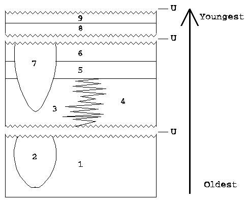
[U= Unconformities]
Unit No. |
Unit Name |
Depositional Environment |
Thickness |
1 |
Capella Creek Group and Erebus beds | Shallow Marine | ~2000m |
2 |
Mount Morgan Trondhjemite | Granitic Intrusion | N/A |
3 |
Mount Hoopbound and Balaclava Formations | Dominantly terrestrial with some shallow marine | ~2400m |
4 |
Mount Alma Formation | Deep Marine | ~4000m |
5 |
Rockhampton Group | Shallow Marine | 2000m |
6 |
Youlambie Conglomerate | Terrestrial | ~1500m |
7 |
Bouldercombe Complex | Granitic Intrusion | N/A |
8 |
Precipice Sandstone | Terrestrial | ~50m |
9 |
Stanwell Coal Measures | Initially marine but becomes terrestrial. | Not known |
A comparison with Dr Walker's model shows that there are several things to note about the geology of the Yarrol Province.
|
|
It's
large. The approximate volume is 350,000km3 of
rock, easily fitting Dr Walker's "Continental" scale of geological features. |
|
|
It
contains abundant pyroclastic volcanics. |
|
|
It contains abundant fossils. |
Given the large size of the Yarrol Province it could be classified as either part of the "Creation" event or the "Flood" event. However, according to Dr Walker, abundant pyroclastic volcanics and fossils are inconsistent with his interpretation of the "Creation" event. Therefore, using these three criteria it is obvious from Dr Walker's model that the Yarrol Province was deposited during the flood, and all ~10km of sedimentary rock were deposited in the first 60 days of the flood.
However, when you look in detail at the geology of the Yarrol Province you see that it is impossible for it to fit into such a small time frame.
PROBLEM 1 - GRANITES
As you can see in the diagram above, the sequence of rocks are intruded by two granites, the Mount Morgan Trondhjemite (Unit 2) and the Bouldercombe Complex (Unit 7). There are many more, but these are all that is needed for my demonstration of the failings of Dr Walker's model.
From geological evidence it is obvious that these granites were two separate events. The Mount Morgan Trondhjemite intrudes the Capella Creek Group (part of Unit 1), the granite is then cooled and unroofed (exposed to the surface by erosion).
The Mount Morgan Trondhjemite and Capella Creek Group are then overlain by the Mount Hoopbound and Balaclava Formations (Unit 3), Mount Alma Formations (Unit 4), Rockhampton Group (Unit 5), and Youlambie Conglomerate (Unit 6). Clasts of the Mount Morgan Trondhjemite are commonly found in the basal beds of the Mount Hoopbound and Balaclava Formation.
After deposition of the Youlambie Conglomerate the Yarrol Province is intruded by the second granite, the Bouldercombe Complex (Unit 7). This granite also intrudes the Capella Creek Group and the Mount Alma Formation, but this would have been too difficult to show on the diagram. Once again the granite is cooled and unroofed and then overlain by the Precipice Sandstone (Unit 8) and Stanwell Coal Measures (Unit 9).
The important point of this is that there are two entirely separate granitic intrusion events in the Yarrol Province. One granite is intruded, cools, crystallises and is unroofed. It is then overlain by several kilometres of sedimentary rocks that are then intruded by another granite that also cools, crystallises and is unroofed. This second granite is then also covered by sedimentary rocks.
The problem here is that granites take a long time to cool down. Even a recent creationist paper [9] noted that it would take as short a period of time as 3500 years to cool down a granite. If they could have found a quicker time I am sure that they would have used it. Also, the granites mentioned above are much bigger than the example used in the creationist paper, however, I will use 3500 years as the minimum time needed to cool the granites. There are two entirely separate intrusions in the Yarrol Province and both would have required 3500 years to cool, and both intrude into and are overlain by rocks that Dr Walker would classify as flood deposits. Therefore, Dr Walker wants to force 7000 years of granite cooling into a period of 60 days. More time would be needed to emplace the granites and unroof them, but clearly, even the time needed to cool the granites greatly exceeds Dr Walker's time frames.
Dr Walker tries to claim that the granites could have been cooled quickly by water, [10] but this does not solve the problem. Granites are always coarsely crystalline rocks. If molten rock is cooled quickly the result is a fine-grained lava-like rock or even a volcanic glass. There is no way to cool molten rock quickly enough and still have it produce intrusions with a granitic texture.
PROBLEM 2 - ALLOCHTHONOUS BLOCKS AND MICROFOSSILS
["Allochthonous" is just a big word for "no longer in place."]
The Mount Alma Formation (Unit 4) was deposited in a deep marine environment, in water depths between 750m and 1000m. Fine-grained sandstone, siltstone and mudstone dominate the unit. The siltstones contain microscopic fossils called radiolarians that can only settle out of water in very quiet conditions. The microscopic fossils are very fragile and some possess very delicate spines that project from the fossil. There are also some coarse-grained units in the formation caused by submarine avalanches (mass flows). Near the base of the Mount Alma Formation are large allochthonous blocks of rock from the underlying Erebus beds (part of Unit 1). It is thought that the geological event that caused the unconformity at the base of the Mount Alma Formation lifted up parts of the Erebus beds and caused large blocks to break off the raised areas and slide into the deep marine environments. Most of the blocks are relatively small and are about 100m long, however, some are over 2km long.
Dr Walker interprets the unconformity that unroofed the Mount Morgan Tonalite to be caused by the very strong water currants of the flood [10] and would therefore probably assume that the large blocks of rock were moved by the water currents.
It is impossible to have a water current strong enough to move blocks of rock over 2km long, yet gentle enough to allow microscopic fossils to settle out of water. Also, despite their delicate nature, the microscopic fossils are not broken, indicating that they could not have been deposited by "intense" and "severe" flood conditions.
PROBLEM 3 - REEFS
The Rockhampton Group (Unit 5) was deposited in a shallow, warm, marine environment, and patch reefs have been identified within the unit. [11] The patch reefs range from small mounds 4-10m in diameter and 1m thick, to large complexes more than 50m diameter and 7m thick. It is known that the reefs are preserved in the place in which they formed since their bases are gradational with the underlying sedimentary rocks. The reefs contain an abundant and varied fauna and would have had a complex ecosystem broadly similar to modern reefs.
These reefs with their complex ecosystems would have taken years or decades to form. Not the days required by Dr Walker's model.
PROBLEM 4 - FOOTPRINTS
Dinosaur footprints are relatively common in the Precipice Sandstone (Unit 8). Once again Dr Walker has the problem that dinosaurs would have had to swim in ocean currants strong enough to deposit 10km of sedimentary rock and move blocks of rock over 2km long, and then towards the end when deposition is almost over they would have had to swim down to, and walk around on, the sea floor.
CONCLUSION
Areas of complex geology such as the Yarrol Province highlight many features that cannot be explained by Dr Walker's model.
OVERALL CONCLUSION
If you apply geological knowledge in a superficial or childish way then Dr Walker's model appears to fit the evidence. However when you look at the geological evidence in a more detailed way it is obvious that Dr Walker's model, based on the Flood story of the Bible, fails totally. Since the only real test of a scientific model is how well it can be applied to the real world, it can be conclusively stated that Dr Walker's model has no scientific value.
The source of information upon which Dr Walker based his model (the Bible's Book of Genesis) is useless when it comes to understanding the geology of the world.
REFERENCES
[1] In the "Letters to the Editor" section of The Australian Geologist Newsletter ISSN 0312-4711. In issue No. 111 I asked the question "what physical evidence he (Dr Walker) would accept that would change his opinion about the Bible being scientifically accurate". In issue No. 112 his response was "I do not use science to decide whether the Bible is right. I assume it is". [Return to Text]
[2] In the "Letters to the Editor" section of The Australian Geologist Newsletter ISSN 0312-4711, issue No. 110. [Return to Text]
[3] Smart, J., Grimes, K.G., Doutch, H.F., & Pinchin, 1980: "The Carpentaria and Karumba Basins, North Queensland." BMR Bulletin.202. [Return to Text]
[4] See diagrams of outcrops in; Archer, M, Hand, S.J., & Godthelp, H., 1991: Riversleigh. "The story of animals in ancient rainforests of inland Australia". [Return to Text]
[5] Summarised from; Day, R.W., Whitaker, W.G, Murray, C.G., Wilson, I.H., & Grimes, K.G., 1983: Queensland Geology. A companion volume to the 1:2 500 000 scale geological map (1975). Geological Survey of Queensland Publication 383. [Return to Text]
[6] Olgers, F., 1972: Geology of the Drummond Basin, Queensland. Department of Mineral and Energy, Bureau of Mineral Resources, Geology, and Geophysics Bulletin 132. [Return to Text]
[7] Withnall, I.W., Blake, P.R., Crouch, S.B.S., Tenison Woods, K., Grimes, K.G., Hayward, M.A., Lam, J.S., Garrad, P., & Rees, I.D., 1995: Geology of the southern part of the Anakie Inlier, central Queensland. Queensland Geology 7. [Return to Text]
[8] Some details on the Yarrol Province can be found in; "YARROL PROJECT TEAM*, 1997: New insights into the geology of the northern New England Orogen in the Rockhampton-Monto region, central coastal Queensland: Progress report on the Yarrol Project". Queensland Government Mining Journal, May 1997 edition. [Return to Text]
[9] Snelling, A.A. and J. Woodmorappe, 1998, "The Cooling of Thick Igneous Bodies on a Young Earth, Proceedings of the Fourth International Conference on Creationism, Aug. 3-8, Pittsburgh, PA, USA, Technical Symposium Sessions", R. E. Walsh (ed.), Creation Science Fellowship, Inc., 705 Washington Dr., Pittsburgh, PA, USA 15229, p. 527-545. [Return to Text]
[10] In the "Letters to the Editor" section of The Australian Geologist Newsletter ISSN 0312-4711, issue No. 112. [Return to Text]
[11] Webb, G.E., 1998: "Earliest known Carboniferous shallow-water reefs, Gudman Formation (Tn1b), Queensland, Australia: Implications for Late Devonian reef collapse and recovery." Geology vol. 26 no.10, p.951-954. [Return to Text]
[12] Some more articles on "Noah's
Flood".
[Return to Text]
Sarfati's Bogus Flood Geology
Can Noah's Flood Account for the Geologic and Fossil Record?
The Geologic Column and its Implications for the Flood
What Would We Expect to Find if the World Had Flooded?
The Insurmountable Problems Associated With "Noah's Ark"
A review of YEC M.J. Oard's "Flood Geology"
![]()